Place Names of New Brunswick: Where is Home? New Brunswick Communities Past and Present
 Introduction |
  Alphabetical Listing |
  County Listing |
  Indexes |
  Definitions
 Skip Navigation Links
Located on E side of the Digdeguash River, 6.14 km SSE of
Whittier Ridge:
Saint Patrick Parish,
Charlotte County: included Saint Patrick: PO 1859-1875: in 1871
Saint Patrick had a population of 250: in 1898 Saint Patrick was a lumbering, milling and shipbuilding commuity: PO
Elmsville 1875-1948: in 1866 Elmsville was a farming settlement with about 20 families: in 1898 Elmsville was a settlement with 1 post office, 2 churches and a population of 200: also included
Dyer, a station on the New Brunswick Southern Railway, located 2.27 km NW of Elmsville.
Latitude
:
45° 16'
Longitude
:
67° 1'
County
:
Charlotte
Parish
:
Saint Patrick
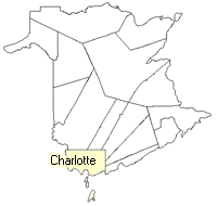
County location in province

 County map showing parishes
 Zoom in

Cadastral Maps
New Brunswick cadastral maps show the basic features of the province along with the boundaries, lot number, and grantee’s name for land granted by the province. These maps are cumulative, showing all grants regardless of date.
Zoom in

or
download
the full size version.
2805 x 3941 - 2.7 mb
|