Place Names of New Brunswick: Where is Home? New Brunswick Communities Past and Present
 Introduction |
  Alphabetical Listing |
  County Listing |
  Indexes |
  Definitions
 Skip Navigation Links
Located 3.91 km E of
Renforth and 12.89 km NNE of
Saint John city centre:
Simonds Parish,
St. John County: settled in 1819: formerly called Marks Settlement for William Marks, who was a settler at Marks Lake: PO
Golden Grove Mills 1878-1922: PO
Golden Grove 1885-1932: in 1898 Golden Grove was a fishing resort and a farming community with 1 post office, 1 woollen mill, 3 churches and a population of 350: now within the city of Saint John.
Latitude
:
45° 22'
Longitude
:
65° 58'
County
:
St. John
Parish
:
Simonds
County location in province

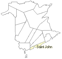 County map showing parishes
 Zoom in

Cadastral Maps
New Brunswick cadastral maps show the basic features of the province along with the boundaries, lot number, and grantee’s name for land granted by the province. These maps are cumulative, showing all grants regardless of date.
Zoom in

or
download
the full size version.
3782 x 2794 - 2.6 mb
|