Place Names of New Brunswick: Where is Home? New Brunswick Communities Past and Present
 Introduction |
  Alphabetical Listing |
  County Listing |
  Indexes |
  Definitions
 Skip Navigation Links
Located on E side of the St. John River across from
Simonds, 3.92 km NNW of
Hartland:
Brighton Parish,
Carleton County: possibly named for Frederick Harding Hale, (1844-1912) who was a Member of Parliament from 1887-1891 and 1896-1904: Hale became part of
Upper Brighton.
Latitude
:
46° 20'
Longitude
:
67° 33'
County
:
Carleton
Parish
:
Brighton
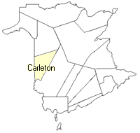
County location in province

 County map showing parishes
 Zoom in

Cadastral Maps
New Brunswick cadastral maps show the basic features of the province along with the boundaries, lot number, and grantee’s name for land granted by the province. These maps are cumulative, showing all grants regardless of date.
Zoom in

or
download
the full size version.
3652 x 2747 - 2.6 mb
|