Place Names of New Brunswick: Where is Home? New Brunswick Communities Past and Present
 Introduction |
  Alphabetical Listing |
  County Listing |
  Indexes |
  Definitions
 Skip Navigation Links
Located on E side of the St. John River across from
Somerville, 3.92 km SSE of
Simonds:
Brighton Parish,
Carleton County: William Francis Ganong identified the Maliseet name for this area as Abekaguim'ek or "salmon bed": PO Becaguimic 1852-1868: in 1866 Becaguimic was a farming community with about 80 families: renamed Hartland in 1868 for James R. Hartley (1833-1868), a Member of the Legislative Assembly for Carleton County: PO
Hartland from 1868: in 1871 Hartland had a population of 400: in 1898 Hartland was the commercial centre of an extensive agricultural district, a station on the Canadian Pacific Railway and a village with 1 post office, 12 stores, 3 hotels, 1 sawmill, 1 woodworking factory, 1 cheese factory, 4 churches and a population of 400: Hartland was incorporated as a town in 1918: Hartland is the site of the longest covered bridge in the world.
Latitude
:
46° 18'
Longitude
:
67° 32'
County
:
Carleton
Parish
:
Brighton
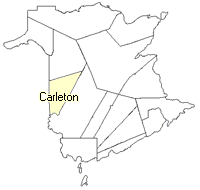
County location in province

 County map showing parishes
 Zoom in

Cadastral Maps
New Brunswick cadastral maps show the basic features of the province along with the boundaries, lot number, and grantee’s name for land granted by the province. These maps are cumulative, showing all grants regardless of date.
Zoom in

or
download
the full size version.
3694 x 2760 - 2.5 mb
|