Place Names of New Brunswick: Where is Home? New Brunswick Communities Past and Present
 Introduction |
  Alphabetical Listing |
  County Listing |
  Indexes |
  Definitions
 Skip Navigation Links
Located on Newcastle Creek, 16.91 km WSW of
Chipman:
Northfield Parish,
Sunbury County and
Canning Parish,
Queens County: named for Gilbert John Elliot, 4th Earl of Minto (1845-1914) and governor-general of Canada from 1898-1904: coal mining has been carried out in this area since the 1760's: PO
Minto from 1904: in 1904 Minto was the terminus of the Central Railway and a village with 1 post office: Included
Northfield PO 1857-1923;
Newcastle Bridge, PO from 1862;
Rothwell, PO from 1914:
South Minto,PO 1915-1929; North Minto, PO 1924-1969;
New England Settlement, PO 1935-1961 : Minto was incorporated as a village in 1966.
Latitude
:
46° 5'
Longitude
:
66° 4'
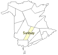
County
:
Sunbury
Parish
:
Sheffield
County location in province

 County map showing parishes
 Zoom in

Cadastral Maps
New Brunswick cadastral maps show the basic features of the province along with the boundaries, lot number, and grantee’s name for land granted by the province. These maps are cumulative, showing all grants regardless of date.
Zoom in

or
download
the full size version.
3780 x 2705 - 2.9 mb
|