Place Names of New Brunswick: Where is Home? New Brunswick Communities Past and Present
 Introduction |
  Alphabetical Listing |
  County Listing |
  Indexes |
  Definitions
 Skip Navigation Links
Located 1.29 km E of
Minto, on the road to
Newcastle Centre:
Canning Parish,
Queens County: PO from 1862: in 1866 Newcastle Bridge was a farming community with approximately 30 resident families, including 6 Yeaman families: in 1871 it had a population of 200: in 1898 Newcastle Bridge had 1 post office, 1 store, 1 sawmill, 2 churches, coal mines nearby and a population of 150: Newcastle Bridge became part of Minto.
Latitude
:
46° 5'
Longitude
:
66° 3'
County
:
Queens
Parish
:
Canning
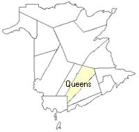
County location in province

 County map showing parishes
 Zoom in

Cadastral Maps
New Brunswick cadastral maps show the basic features of the province along with the boundaries, lot number, and grantee’s name for land granted by the province. These maps are cumulative, showing all grants regardless of date.
Zoom in

or
download
the full size version.
3780 x 2705 - 2.9 mb
|