Place Names of New Brunswick: Where is Home? New Brunswick Communities Past and Present
 Introduction |
  Alphabetical Listing |
  County Listing |
  Indexes |
  Definitions
 Skip Navigation Links
Located at the mouth of the Magaguadavic River, 9.36 km S of
Bonny River and 5.71 km NNE of
Letang:
Saint George Parish,
Charlotte County: surveyed in 1786: first called Magaguadavic and then renamed Granite Town for the red-granite quarries nearby: renamed St. George in 1829: PO from 1829: in 1871 it had a population of 600: in 1898 St. George was a port of entry on the Shore Line Railway and a community with 1 post office, 22 stores, 3 hotels, 1 sawmill, 1 grist mill, 4 churches and a population of 1,000: St. George was incorporated as a town in 1904.
Latitude
:
45° 8'
Longitude
:
66° 50'
County
:
Charlotte
Parish
:
Saint George
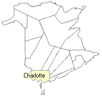
County location in province

 County map showing parishes
 Zoom in

Cadastral Maps
New Brunswick cadastral maps show the basic features of the province along with the boundaries, lot number, and grantee’s name for land granted by the province. These maps are cumulative, showing all grants regardless of date.
Zoom in

or
download
the full size version.
2750 x 3903 - 2.9 mb
|
Zoom in

or
download
the full size version.
2858 x 3795 - 1.7 mb
|