Place Names of New Brunswick: Where is Home? New Brunswick Communities Past and Present
 Introduction |
  Alphabetical Listing |
  County Listing |
  Indexes |
  Definitions
 Skip Navigation Links
Located on the Bay of Fundy, 3.21 km SW of
Lorneville on the road to
Black Beach and 15.27 km SW of
Saint John:
Lancaster Parish,
St. John County: formerly called Irishtown: in 1866 Irishtown was a fishing community with approximately 25 families: included the settlement of Pisarinco West: PO
Pisarinco West 1893-1902: PO
Seaview 1903-1913: Seaview is now within the city of Saint John.
Latitude
:
45° 10'
Longitude
:
66° 11'
County
:
St. John
Parish
:
Lancaster
County location in province

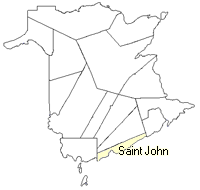 County map showing parishes
 Zoom in

Cadastral Maps
New Brunswick cadastral maps show the basic features of the province along with the boundaries, lot number, and grantee’s name for land granted by the province. These maps are cumulative, showing all grants regardless of date.
Zoom in

or
download
the full size version.
2783 x 3909 - 2.4 mb
|