GNB
Provincial Archives of New Brunswick

Place Names of New Brunswick: Where is Home? New Brunswick Communities Past and Present

Community name search   

home Introduction |  home Alphabetical Listing |  home County Listing |  home Indexes |  home Definitions


arrow Stevens
Skip Navigation Links
Description
Located in Saint John West: Lancaster Parish, Saint John County: in 1902 the Canadian Pacific Railway changed the name of the station located here to Acamac: PO Stevens 1880-1958: Stevens is now in the city of Saint John.

Latitude : 45° 16'

Longitude : 66° 3'

County : St. John

Parish : Lancaster

County location in province
---
SaintJohn

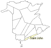
County map showing parishes
---
+ Zoom in
SaintJohn

Cadastral Maps
---
New Brunswick cadastral maps show the basic features of the province along with the boundaries, lot number, and grantee’s name for land granted by the province. These maps are cumulative, showing all grants regardless of date.

+ Zoom in
GM165-3896
or download the full size version.
4912 x 3485 - 3.5 mb


Other communities within the vicinity of    

CommunityDistance (Kilometers)Bearing
Little River 1.31 90° E
Negrotown Point 2.27 215° SW
West Saint John 2.27 215° SW
Westmorland Heights 2.27 35° NE
Saint John East 2.27 35° NE
Saint John West 2.27 215° SW
Disbrowville 2.27 35° NE
East Saint John 2.27 35° NE
Midwood 2.61 90° E
Marble Cove 2.61 270° W
Navy Island 2.61 270° W
Ouigoudi 2.61 270° W
Union Point Road 2.61 270° W
Union Point 2.61 270° W
Indiantown 3.2 305° NW
Red Head 3.2 125° SE
Fundy Heights 3.2 235° SW
Partridge Island 3.71 180° S
Pleasant Point 3.92 270° W
Point Pleasant 3.92 270° W
Kingsville 3.92 270° W
Milford 3.92 270° W
Simms Corner 3.92 270° W
St. Marysville 3.92 270° W
Bay Shore 3.93 199° SSW
Eastmount 3.93 19° NNE
Fairville 4.33 245° WSW
Fairville Plateau 4.33 245° WSW
Glenburnie 4.33 295° WNW
Duck Cove 4.33 245° WSW
Champlain Heights 4.33 65° ENE
Lancaster 4.33 245° WSW
Greendale 4.33 245° WSW
Pokiok 4.33 295° WNW
Mahogany Road 4.33 245° WSW
Lancaster Vale 4.33 245° WSW
Silver Falls 4.53 35° NE
Silver Falls Park 4.53 35° NE
Anthonys Cove 4.53 145° SE
* Distances and bearings were calculated by using the latitude and longitude of the community.


4.11.1