Place Names of New Brunswick: Where is Home? New Brunswick Communities Past and Present
 Introduction |
  Alphabetical Listing |
  County Listing |
  Indexes |
  Definitions
 Skip Navigation Links
Located 3.12 km NE of
Fairisle, on the road to
Tabusintac:
Alnwick Parish,
Northumberland County: PO
Neguac 1857-1873: PO
Stymast Settlement 1873-1890 with John Stymast as postmaster: included the settlement of
Morrissy: possibly named for John Morrissy who was a member of the Legislative Assembly of New Brunswick: PO
Morrissy 1927-1957.
Latitude
:
47° 18'
Longitude
:
65° 5'
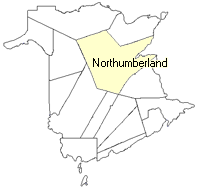
County
:
Northumberland
Parish
:
Alnwick
County location in province

 County map showing parishes
 Zoom in

Cadastral Maps
New Brunswick cadastral maps show the basic features of the province along with the boundaries, lot number, and grantee’s name for land granted by the province. These maps are cumulative, showing all grants regardless of date.
Zoom in

or
download
the full size version.
3644 x 2774 - 1.6 mb
|