Place Names of New Brunswick: Where is Home? New Brunswick Communities Past and Present
 Introduction |
  Alphabetical Listing |
  County Listing |
  Indexes |
  Definitions
 Skip Navigation Links
Located on the Washademoak Lake, 5.71 km NNW of
Salmon Creek, on the road to
Codys:
Johnston Parish,
Queens County: PO 1864-1910: in 1866 Thornetown was a farming community with about 30 families including the families of Abraham Thorne, Butler Thorne, C.W. Thorne, Charles A. Thorne, Frederick Thorne, George Thorne, Isaac N. Thorne, Jacob Thorne, James Thorne, James A. Thorne, James T. Thorne, Michael Thorne, Thomas Thorne and William A. Thorne: in 1871 Thornetown had a population of 150: in 1898 it had 1 post office, 1 store, 1 tannery, 1 church and a population of about 150.
Latitude
:
45° 52'
Longitude
:
65° 51'
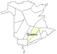
County
:
Queens
Parish
:
Johnston
County location in province

 County map showing parishes
 Zoom in

Cadastral Maps
New Brunswick cadastral maps show the basic features of the province along with the boundaries, lot number, and grantee’s name for land granted by the province. These maps are cumulative, showing all grants regardless of date.
Zoom in

or
download
the full size version.
3751 x 2756 - 2.4 mb
|