Place Names of New Brunswick: Where is Home? New Brunswick Communities Past and Present
 Introduction |
  Alphabetical Listing |
  County Listing |
  Indexes |
  Definitions
 Skip Navigation Links
Located 3.91 km NNE of
Sheila:
Saumarez Parish,
Gloucester County: William Francis Ganong identified the Mi'kmaq name for Tracadie as
Tulakadik or "camping ground": settled in 1785 by the Acadians and later by the Scottish: PO
Tracady 1845-1851: PO
Tracadie from 1851: in 1866 Tracadie was a farming, lumbering and fishing community with approximately 120 resident families: in 1871 Tracadie had a population of 1,200: in 1898 it was a station on the Caraquet and Gulf Shore Railway and had 1 post office, 5 stores, 2 hotels, 1 grist mill, 2 sawmills, 2 churches and a population of about 1,400: included
Brideau Settlement,
Dignard, and
Basque: Tracadie was incorporated as a town in 1966, and in 1992 it joined with Sheila to form Tracadie-Sheila.
Latitude
:
47° 31'
Longitude
:
64° 54'
County
:
Gloucester
Parish
:
Saumarez
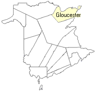
County location in province

 County map showing parishes
 Zoom in

Cadastral Maps
New Brunswick cadastral maps show the basic features of the province along with the boundaries, lot number, and grantee’s name for land granted by the province. These maps are cumulative, showing all grants regardless of date.
Zoom in

or
download
the full size version.
3791 x 2815 - 2.9 mb
|