Place Names of New Brunswick: Where is Home? New Brunswick Communities Past and Present
 Introduction |
  Alphabetical Listing |
  County Listing |
  Indexes |
  Definitions
 Skip Navigation Links
Located on E side of the St. John River, 4.26 km ENE of
Florenceville:
Kent Parish,
Carleton County: first known as Shikatehawk after the name of a nearby stream: William Francis Ganong identified the name Shikatehawk as a derivitive of the Maliseet word Shigateehawg': PO 1866-1878: in 1866 Shikatehawk was a farming settlement with about 20 families: in 1871 it had a population of 150: renamed Bristol for the city of Bristol in England: PO
Bristol from 1878: in 1898 Bristol was a station on the Canadian Pacific Railway and a community with 1 post office, 6 stores, 2 hotels, 1 sawmill, 1 grist mill, 1 carding mill, 1 woodworking factory, 1 church and a population of 300: included Kent Station: Bristol was incorporated as a village in 1966. It amalgamated with the adjacent village of Florenceville in 2008 to form Florenceville-Bristol.
Latitude
:
46° 28'
Longitude
:
67° 35'
County
:
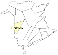
Carleton
Parish
:
Kent
County location in province

 County map showing parishes
 Zoom in

Cadastral Maps
New Brunswick cadastral maps show the basic features of the province along with the boundaries, lot number, and grantee’s name for land granted by the province. These maps are cumulative, showing all grants regardless of date.
Zoom in

or
download
the full size version.
3652 x 2747 - 2.6 mb
|