Place Names of New Brunswick: Where is Home? New Brunswick Communities Past and Present
 Introduction |
  Alphabetical Listing |
  County Listing |
  Indexes |
  Definitions
 Skip Navigation Links
Located 3.16 km NE of
Bloomfield:
Wilmot Parish,
Carleton County: originally called Crandlemire Settlement and renamed Brookville in 1868: ("At a public meeting held at Crandlemire Settlement,
Parish of Simonds,
Carleton County, 4th May last, it was decided to change the name of the settlement to Brookville." Carleton Sentinel, July 11, 1868.): PO
Brookville 1880-1916: in 1898 Brookville was a settlement with 1 post office, 1 church and a population of 200.
Latitude
:
46° 20'
Longitude
:
67° 44'
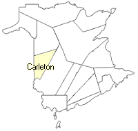
County
:
Carleton
Parish
:
Wilmot
County location in province

 County map showing parishes
 Zoom in

Cadastral Maps
New Brunswick cadastral maps show the basic features of the province along with the boundaries, lot number, and grantee’s name for land granted by the province. These maps are cumulative, showing all grants regardless of date.
Zoom in

or
download
the full size version.
3652 x 2747 - 2.6 mb
|