Place Names of New Brunswick: Where is Home? New Brunswick Communities Past and Present
 Introduction |
  Alphabetical Listing |
  County Listing |
  Indexes |
  Definitions
 Skip Navigation Links
Located at the mouth of the Upper Salmon River, E of Fundy National Park, 9.81 km WSW of
Waterside:
Alma Parish,
Albert County: settled in 1810 by settlers from Nova Scotia and called Salmon River: PO
Salmon River 1848-1873: in 1871 Salmon River had a population of 250: renamed Alma in 1873: PO
Alma from 1873: in 1904 Alma was a terminus of the Albert Southern Railway and a settlement with 1 post office, 5 stores, 3 hotels, 3 sawmills, 2 churches and a population of 350: included the community of
Alma West which is now within Fundy National Park: PO
Alma West 1923-1949: Alma was incorporated as a village in 1966.
Latitude
:
45° 36'
Longitude
:
64° 57'
County
:
Albert
Parish
:
Alma
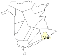
County location in province

 County map showing parishes
 Zoom in

Cadastral Maps
New Brunswick cadastral maps show the basic features of the province along with the boundaries, lot number, and grantee’s name for land granted by the province. These maps are cumulative, showing all grants regardless of date.
Zoom in

or
download
the full size version.
3802 x 2759 - 1.5 mb
|