Place Names of New Brunswick: Where is Home? New Brunswick Communities Past and Present
 Introduction |
  Alphabetical Listing |
  County Listing |
  Indexes |
  Definitions
 Skip Navigation Links
Located on E side of the St. John River, 5.37 km WSW of
Pelletiers Mill:
Saint-François Parish,
Madawaska County: first called Upper St. Francis: PO
Upper St. Francis 1871-1893: renamed for Robert Connors, a lumberman (1835-1895) who was originally from Nova Scotia: PO
Connor 1893-1947: in 1898 Connors was a station on the Témiscouata Railway and a settlement with 1 post office, 2 stores, 1 hotel, 1 sawmill, 2 churches and a population of 200: PO
Connors 1947-1958.
Latitude
:
47° 13'
Longitude
:
68° 50'
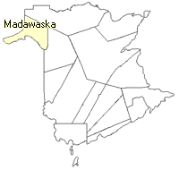
County
:
Madawaska
Parish
:
Saint-François
County location in province

 County map showing parishes
 Zoom in

Cadastral Maps
New Brunswick cadastral maps show the basic features of the province along with the boundaries, lot number, and grantee’s name for land granted by the province. These maps are cumulative, showing all grants regardless of date.
Zoom in

or
download
the full size version.
3758 x 2990 - 1.9 mb
|