Place Names of New Brunswick: Where is Home? New Brunswick Communities Past and Present
 Introduction |
  Alphabetical Listing |
  County Listing |
  Indexes |
  Definitions
 Skip Navigation Links
Located on Chaleur Bay, 6.7 km NW of
Pointe-Verte:
Beresford Parish,
Gloucester County and
Durham Parish,
Restigouche County: William Francis Ganong identified the Mi'kmaq name for Belledune as Meskeeneegeach': settled by Irish immigrants in 1825 and and later by Scottish immigrants in 1832: PO from 1845: in 1866 Belledune was a farming, fishing and lumbering community with approximately 40 resident families: in 1871 it had a population of about 400: in 1904 Belledune was on the Intercolonial Railway and had 1 post office, 4 stores, 1 hotel, 2 churches and a population of 450: included the community of
Turgeon: PO
Turgeon 1905-1966: Belledune was incorporated as a village in 1968: today Belledune is a deep-water harbour and the site of an industrial complex.
Latitude
:
47° 54'
Longitude
:
65° 49'
County
:
Gloucester
Parish
:
Beresford
County location in province

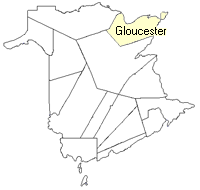 County map showing parishes
 Zoom in

Cadastral Maps
New Brunswick cadastral maps show the basic features of the province along with the boundaries, lot number, and grantee’s name for land granted by the province. These maps are cumulative, showing all grants regardless of date.
Zoom in

or
download
the full size version.
3014 x 2529 - 1.6 mb
|