Place Names of New Brunswick: Where is Home? New Brunswick Communities Past and Present
 Introduction |
  Alphabetical Listing |
  County Listing |
  Indexes |
  Definitions
 Skip Navigation Links
Located beside Shediac Bay 3.85 km E of
Boudreau and 3.85 km W of
Robichaud :
Shediac Parish,
Westmorland County : PO
Barrachois from 1853-1885 : PO
Barachois from 1885 to 1953 : in 1866 Barachois was an agricultural and fishing settlement where 44 families lived, including 17 Boudreau families, 16 Légère families: in 1871 the population of the settlement was about 300 : in 1898 Barachois had 1 post office, 1 store, 3 lobster factories, 1 church et a population of about 300 : in 1904 it had a population of 800: also known as
St-Henri-de-Barachois : PO
St-Henri-de-Barachois 1947-1970.
Latitude
:
46° 13'
Longitude
:
64° 26'
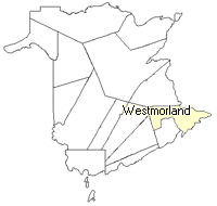
County
:
Westmorland
Parish
:
Shediac
County location in province

 County map showing parishes
 Zoom in

Cadastral Maps
New Brunswick cadastral maps show the basic features of the province along with the boundaries, lot number, and grantee’s name for land granted by the province. These maps are cumulative, showing all grants regardless of date.
Zoom in

or
download
the full size version.
3676 x 2881 - 2 mb
|