Place Names of New Brunswick: Where is Home? New Brunswick Communities Past and Present
 Introduction |
  Alphabetical Listing |
  County Listing |
  Indexes |
  Definitions
 Skip Navigation Links
Located 11 km ENE of
Cedar Camp and 7.98 km ESE of
South Branch:
Cardwell Parish,
Kings County: founded in 1843 by a group of mechanics and labourers from
Saint John: the tract included lands at the head of the Kennebecasis, Pollett and Little Rivers: PO 1853-1928: in 1866 Mechanic Settlement was a farming community with 50 families: in 1871 it had a population of 250 with only 1 family of the original settlers remaining: in 1898 Mechanic Settlement had 1 post office, 1 store, 1 sawmill, 1 grist mill, 2 churches and a population of 275.
Latitude
:
45° 44'
Longitude
:
65° 12'
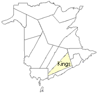
County
:
Kings
Parish
:
Cardwell
County location in province

 County map showing parishes
 Zoom in

Cadastral Maps
New Brunswick cadastral maps show the basic features of the province along with the boundaries, lot number, and grantee’s name for land granted by the province. These maps are cumulative, showing all grants regardless of date.
Zoom in

or
download
the full size version.
3630 x 2741 - 2.9 mb
|