Place Names of New Brunswick: Where is Home? New Brunswick Communities Past and Present
 Introduction |
  Alphabetical Listing |
  County Listing |
  Indexes |
  Definitions
 Skip Navigation Links
Located on the Kennebecasis River, 6.74 km WSW of
Sussex:
Sussex Parish and
Studholm Parish,
Kings County: set up in 1858: pronounced "a-po-hawk": William Francis Ganong identified the Maliseet name for Apohaqui as Apolog'aneek: first called Studholm or Studville for Gilfred Studholme (1740-1792) who settled here in 1786: PO
Studholm 1855-1858: in 1866 Studholm was a farming settlement with about 12 resident families: also included Mouth of Millstream: PO 1852-1868: in 1866 Mouth of Millstream was a farming community with approximately 29 families including 6 Secord families: PO
Apohaqui from 1868: in 1871 Apohaqui had a population of 300: in 1898 Apohaqui was a station on the Intercolonial Railway and a farming community with 1 post office, 2 stores, 1 hotel, 1 carriage shop, 1 machine shop, 1 cheese factory, 3 churches and a population of 350.
Latitude
:
45° 42'
Longitude
:
65° 36'
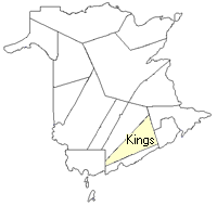
County
:
Kings
Parish
:
Sussex
County location in province

 County map showing parishes
 Zoom in

Cadastral Maps
New Brunswick cadastral maps show the basic features of the province along with the boundaries, lot number, and grantee’s name for land granted by the province. These maps are cumulative, showing all grants regardless of date.
Zoom in

or
download
the full size version.
3594 x 2778 - 2.5 mb
|