Place Names of New Brunswick: Where is Home? New Brunswick Communities Past and Present
 Introduction |
  Alphabetical Listing |
  County Listing |
  Indexes |
  Definitions
 Skip Navigation Links
Located on E side of the Petitcodiac River, 3.93 km SSE of
Pré-d'en-Haut:
Dorchester Parish,
Westmorland County: named for Pierre Belliveau who was a settler in the area: PO
Belliveau-Village 1853-1953: in 1866 Belliveau-Village was a farming and fishing settlement with approximately 91 resident families, including 24 Belliveau, 15 Bourgeois and 24 White (LeBlanc) families: in 1871 it had a population of 200: in 1898 Belliveau-Village had 1 post office, 1 store and a population of 250: by 1904 the population had increased to 350: Belliveau-Village became part of the village of
Memramcook.
Latitude
:
45° 56'
Longitude
:
64° 37'
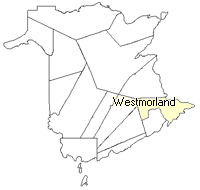
County
:
Westmorland
Parish
:
Dorchester
County location in province

 County map showing parishes
 Zoom in

Cadastral Maps
New Brunswick cadastral maps show the basic features of the province along with the boundaries, lot number, and grantee’s name for land granted by the province. These maps are cumulative, showing all grants regardless of date.
Zoom in

or
download
the full size version.
3760 x 2767 - 2.4 mb
|