Place Names of New Brunswick: Where is Home? New Brunswick Communities Past and Present
 Introduction |
  Alphabetical Listing |
  County Listing |
  Indexes |
  Definitions
 Skip Navigation Links
Located on the Kouchibouguacis River, 4.5 km NW of
Grande-Aldouane, on the road to
Kouchibouguac:
Saint-Louis Parish,
Kent County: formerly called Kouchibouguacis, Petit-Kagibougouette and Palmerston: PO
Palmerston 1868-1879: in 1866 Palmerston was a farming community with about 127 families, including 16 Richard and 12 Johnston families: included Louisville: in 1871 Louisville had a population of 120: PO
St-Louis-de-Kent from 1879: in 1871 it had a population of 600: in 1898 Saint-Louis-de-Kent was a station on the Kent Northern Railway and a settlement with 1 post office, 9 stores, 1 hotel, 1 butter factory, 1 church and convent and a population of 600: Saint-Louis-de-Kent was incorporated as a village in 1966.
Latitude
:
46° 44'
Longitude
:
64° 58'
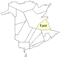
County
:
Kent
Parish
:
Saint-Louis
County location in province

 County map showing parishes
 Zoom in

Cadastral Maps
New Brunswick cadastral maps show the basic features of the province along with the boundaries, lot number, and grantee’s name for land granted by the province. These maps are cumulative, showing all grants regardless of date.
Zoom in

or
download
the full size version.
3671 x 2774 - 2.5 mb
|