Place Names of New Brunswick: Where is Home? New Brunswick Communities Past and Present
 Introduction |
  Alphabetical Listing |
  County Listing |
  Indexes |
  Definitions
 Skip Navigation Links
Located on Bathurst Harbour:
Bathurst Parish,
Gloucester County: first called Nepisiguit in the late 1600's by French settlers: William Francis Ganong identified Nepisiguit as a derivative of the Mi'kmaq word Winpegijawik, or "rough water," which referred to the river: renamed for Henry Bathurst, 3rd Earl of Bathurst (1762-1834): PO from 1825: in 1866 Bathurst was a community with approximately 130 resident families: included St. Peters: in 1866 St. Peters was a farming, lumbering and shipbuilding community with approximately 114 resident families and in 1871 it had a population of 600: also included the community of Nepisiguit which in 1871 had a population of 300: in 1871 Bathurst had a population of 600: in 1904 Bathurst was a seaport, a port of entry on the Intercolonial Railway and the Caraquet and Gulf Shore Railway and a town with 1 post office, 35 stores, 6 hotels, 1 steam sawmill, 1 shingle mill, 1 flour mill, 3 fish freezers, 2 carriage factories, 1 printing shop, 3 churches and a population of 3,000: Bathurst was incorporated as a town in 1912 and as a city in 1966: see the separate entries for the following communities absorbed by Bathurst:
Middle River,
Moody's,
Roy Settlement,
Sainte-Anne,
Sand Hill,
South Bathurst,
St. Mary,
Vallée-Lourdes, and
West Bathurst.
Latitude
:
47° 36'
Longitude
:
65° 39'
County
:
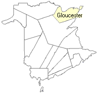
Gloucester
Parish
:
Bathurst
County location in province

 County map showing parishes
 Zoom in

Cadastral Maps
New Brunswick cadastral maps show the basic features of the province along with the boundaries, lot number, and grantee’s name for land granted by the province. These maps are cumulative, showing all grants regardless of date.
Zoom in

or
download
the full size version.
3821 x 2776 - 2.9 mb
|