Place Names of New Brunswick: Where is Home? New Brunswick Communities Past and Present
 Introduction |
  Alphabetical Listing |
  County Listing |
  Indexes |
  Definitions
 Skip Navigation Links
Located on S side of the Miramichi River, 2.53 km E of
Douglastown:
Chatham Parish,
Northumberland County: founded in 1800 by Francis Peabody, a New Englander who moved to Chatham from
Maugerville: first called The Spruce Tree: then renamed Miramichi: PO
Miramichi 1825-1843: renamed Chatham in 1843 for William Pitt, father and son, who both became Earl of Chatham and prime minister of England: PO
Chatham from 1843: in 1871 it had a population of 3,000: in 1898 Chatham was a seaport, a port of entry, a post, money order and postal note office, terminus of the Canada Eastern Railway and a town with 100 stores, 5 hotels, 2 steam sawmills, 2 sulphite pulp mills, 2 foundry and machine shops, 2 marine slips, 2 sash and door factories, 1 brick kiln, 3 carriage and sleigh factories, 3 printing offices, 7 churches and a population of 5,000: Chatham was incorporated as a town in 1896 and is now part of the city of
Miramichi.
Latitude
:
47° 2'
Longitude
:
65° 28'
County
:
Northumberland
Parish
:
Chatham
County location in province

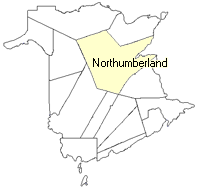 County map showing parishes
 Zoom in

Cadastral Maps
New Brunswick cadastral maps show the basic features of the province along with the boundaries, lot number, and grantee’s name for land granted by the province. These maps are cumulative, showing all grants regardless of date.
Zoom in

or
download
the full size version.
3634 x 2759 - 2.2 mb
|