Place Names of New Brunswick: Where is Home? New Brunswick Communities Past and Present
 Introduction |
  Alphabetical Listing |
  County Listing |
  Indexes |
  Definitions
 Skip Navigation Links
Located near Shepody Bay, 3.93 km NNW of
Harvey:
Hopewell Parish,
Albert County: first called Hopewell Corner: PO 1854-1882: in 1866 Hopewell Corner was a farming and shipping community with approximately 60 resident families: there were 7 sea captains, 5 being members of the Wood family: in 1871 Hopewell Corner had a population of 250: ("The residents of Hopewell Corner held meetings on the 8th and 15th inst. and resolved to change the name of Hopewell Corner, hereafter to be known as Albert. The change had become necessary on account of there being four places within 12 miles of each other called Hopewell."
Morning Freeman, December 24, 1881): PO
Albert from 1882: in 1898 Albert was the terminus of the Salisbury and Harvey Railway and a community with 1 post office, 7 stores, 4 hotels, 1 sawmill, 1 carriage factory, 1 grist mill, 1 tannery, 1 sash and door factory, 1 furniture factory, 2 churches and a population of 500: Albert became part of the village of
Riverside-Albert.
Latitude
:
45° 45'
Longitude
:
64° 44'
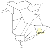
County
:
Albert
Parish
:
Hopewell
County location in province

 County map showing parishes
 Zoom in

Cadastral Maps
New Brunswick cadastral maps show the basic features of the province along with the boundaries, lot number, and grantee’s name for land granted by the province. These maps are cumulative, showing all grants regardless of date.
Zoom in

or
download
the full size version.
2805 x 3861 - 1.9 mb
|