Place Names of New Brunswick: Where is Home? New Brunswick Communities Past and Present
 Introduction |
  Alphabetical Listing |
  County Listing |
  Indexes |
  Definitions
 Skip Navigation Links
Located 2.23 km SW of
Nash Creek:
Durham Parish,
Restigouche County: probably named Doyleville for Joseph Doyle who settled in the
Jacquet River area in 1790: PO
Doyle Settlement 1865-1919: PO
Doyleville 1919-1960 with Patrick Doyle as first postmaster: in 1871 Doyleville had a population of 100: in 1898 Doyleville was a farming community with 1 post office and a population of 100: included Murchie Settlement.
Latitude
:
47° 54'
Longitude
:
66° 6'
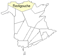
County
:
Restigouche
Parish
:
Durham
County location in province

 County map showing parishes
 Zoom in

Cadastral Maps
New Brunswick cadastral maps show the basic features of the province along with the boundaries, lot number, and grantee’s name for land granted by the province. These maps are cumulative, showing all grants regardless of date.
Zoom in

or
download
the full size version.
3333 x 2786 - 2 mb
|