Place Names of New Brunswick: Where is Home? New Brunswick Communities Past and Present
 Introduction |
  Alphabetical Listing |
  County Listing |
  Indexes |
  Definitions
 Skip Navigation Links
Located 5.56 km S of
Glassville:
Aberdeen Parish,
Carleton County: first called Farley's Mills for Joseph N. Farley: PO
Farley's Mills 1866-1876: in 1871 Farley's Mills had a population of 50: renamed Esdraelon in 1876 for the Plain of Esdraelon, which is located at the foot of Mount Hermon in the Holy Land: PO
Esdraelon 1876-1915: in 1898 Esdraelon had 1 post office, 1 sawmill and a population of 50.
Latitude
:
46° 26'
Longitude
:
67° 25'
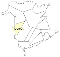
County
:
Carleton
Parish
:
Aberdeen
County location in province

 County map showing parishes
 Zoom in

Cadastral Maps
New Brunswick cadastral maps show the basic features of the province along with the boundaries, lot number, and grantee’s name for land granted by the province. These maps are cumulative, showing all grants regardless of date.
Zoom in

or
download
the full size version.
3684 x 2697 - 2.4 mb
|