Place Names of New Brunswick: Where is Home? New Brunswick Communities Past and Present
 Introduction |
  Alphabetical Listing |
  County Listing |
  Indexes |
  Definitions
 Skip Navigation Links
Located 7.52 km N of
Whitney, on the road to
Chaplin Island Road:
Northesk Parish,
Northumberland County: named Protectionville in 1879 for the protectionist policies of the government of John A. Macdonald: PO 1881-1915: in 1898 Protectionville was a farming and lumbering settlement with 1 post office, 1 store, 1 spool factory, 1 church and a population of 100: renamed Maple Glen in 1915: PO
Maple Glen 1915-1957: included Sugary Settlement and Vanderbeck.
Latitude
:
47° 2'
Longitude
:
65° 43'
County
:
Northumberland
Parish
:
Northesk
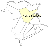
County location in province

 County map showing parishes
 Zoom in

Cadastral Maps
New Brunswick cadastral maps show the basic features of the province along with the boundaries, lot number, and grantee’s name for land granted by the province. These maps are cumulative, showing all grants regardless of date.
Zoom in

or
download
the full size version.
3763 x 2726 - 2.5 mb
|