Place Names of New Brunswick: Where is Home? New Brunswick Communities Past and Present
 Introduction |
  Alphabetical Listing |
  County Listing |
  Indexes |
  Definitions
 Skip Navigation Links
Located 3.71 km S of
Beaver Brook and 3.19 km NW of
New Horton:
Harvey Parish,
Albert County: named for its geographic position midway between
Riverside-Albert and Rocher Bay: PO
Midway 1883-1950: in 1898 Midway was a farming community with 1 post office and a population of 100: included Lowell: PO
Lowell 1894-1934: in 1904 Lowell was a community with 1 post office and a population of 75: also included the settlement of Stevens: PO
Stevens 1908-1909: also included Tingley: PO
Tingley 1909 -1933 in NE part of Midway: in 1866 "Tingley Town" was a farming settlement with about 17 families including 7 Tingley families.
Latitude
:
45° 41'
Longitude
:
64° 46'
County
:
Albert
Parish
:
Harvey
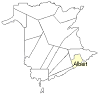
County location in province

 County map showing parishes
 Zoom in

Cadastral Maps
New Brunswick cadastral maps show the basic features of the province along with the boundaries, lot number, and grantee’s name for land granted by the province. These maps are cumulative, showing all grants regardless of date.
Zoom in

or
download
the full size version.
2805 x 3861 - 1.9 mb
|