Place Names of New Brunswick: Where is Home? New Brunswick Communities Past and Present
 Introduction |
  Alphabetical Listing |
  County Listing |
  Indexes |
  Definitions
 Skip Navigation Links
Located on S side of the Tobique River, 5.31 km NE of
Arthurette, on the road to
St. Almo:
Gordon Parish,
Victoria County: named for Jonathan Odell (1737-1818), a Loyalist who was the first provincial secretary of New Brunswick from 1784-1818, and his son William Franklin Odell (1774-1844), second provincial secretary: PO
Odell River 1912-1940.
Latitude
:
46° 49'
Longitude
:
67° 26'
County
:
Victoria
Parish
:
Gordon
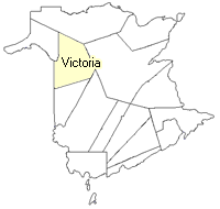
County location in province

 County map showing parishes
 Zoom in

Cadastral Maps
New Brunswick cadastral maps show the basic features of the province along with the boundaries, lot number, and grantee’s name for land granted by the province. These maps are cumulative, showing all grants regardless of date.
Zoom in

or
download
the full size version.
3595 x 2772 - 1.5 mb
|