Place Names of New Brunswick: Where is Home? New Brunswick Communities Past and Present
 Introduction |
  Alphabetical Listing |
  County Listing |
  Indexes |
  Definitions
 Skip Navigation Links
Located at the mouth of the St. Croix River, on a peninsula projecting into Passamaquoddy Bay:
Saint Andrews Parish,
Charlotte County: formerly named Qunnnoskwamk'ook: William Francis Ganong identified this name as the Maliseet word for "long gravel bar": renamed by a French missionary who landed here on St. Andrews Day: settled by Penobscot Loyalists in 1783: PO
St. Andrews from about 1829: in 1898 St. Andrews was a seaport and a port of entry, terminus of the Canadian Pacific Railway and a farming and fishing community with 1 post office, 20 stores, 3 hotels, 2 fish curing establishments, 1 boat-building operation, 5 churches and a population of about 1,800: St. Andrews was a resort destination and was incorporated as a town in 1903.
Latitude
:
45° 5'
Longitude
:
67° 3'
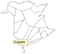
County
:
Charlotte
Parish
:
Saint Andrews
County location in province

 County map showing parishes
 Zoom in

Cadastral Maps
New Brunswick cadastral maps show the basic features of the province along with the boundaries, lot number, and grantee’s name for land granted by the province. These maps are cumulative, showing all grants regardless of date.
Zoom in

or
download
the full size version.
2805 x 3941 - 2.7 mb
|