Place Names of New Brunswick: Where is Home? New Brunswick Communities Past and Present
 Introduction |
  Alphabetical Listing |
  County Listing |
  Indexes |
  Definitions
 Skip Navigation Links
Located on E side of
Lac-Baker, 2.51 km E of
Boundary, on the road to
Lac-Baker:
Lac-Baker Parish,
Madawaska County: possibly named for Bernard-Anselme d' Abbadie-de-Saint-Castin (1689-1720), the commander of Acadia from 1704-1714, or for his father Jean-Vincent d' Abbadie (1652-1707), Baron de Saint-Castin and a settler on the Penobscot River in 1670: PO 1938-1947.
Latitude
:
47° 22'
Longitude
:
68° 41'
County
:
Madawaska
Parish
:
Lac-Baker
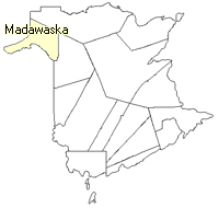
County location in province

 County map showing parishes
 Zoom in

Cadastral Maps
New Brunswick cadastral maps show the basic features of the province along with the boundaries, lot number, and grantee’s name for land granted by the province. These maps are cumulative, showing all grants regardless of date.
Zoom in

or
download
the full size version.
2839 x 3948 - 3 mb
|