Place Names of New Brunswick: Where is Home? New Brunswick Communities Past and Present
 Introduction |
  Alphabetical Listing |
  County Listing |
  Indexes |
  Definitions
 Skip Navigation Links
Located on the South West Branch of the Nicholas River, 3.92 km SSW of
Saint-François-de-Kent:
Wellington Parish,
Kent County: first called Dohertys Mills: PO
Dohertys Mills 1857-1892 with William Doherty as the first postmaster: in 1871 Doherty's Mills had a population of 200: renamed in 1892: PO
St-Grégoire 1892-1955: in 1898 Saint-Grégoire was a farming and lumbering settlement with 1 post office, 3 stores, 1 sawmill, 1 grist mill, 1 church and a population of 200.
Latitude
:
46° 25'
Longitude
:
64° 42'
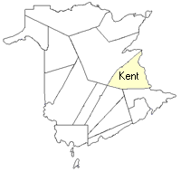
County
:
Kent
Parish
:
Wellington
County location in province

 County map showing parishes
 Zoom in

Cadastral Maps
New Brunswick cadastral maps show the basic features of the province along with the boundaries, lot number, and grantee’s name for land granted by the province. These maps are cumulative, showing all grants regardless of date.
Zoom in

or
download
the full size version.
3616 x 2749 - 2.1 mb
|