Place Names of New Brunswick: Where is Home? New Brunswick Communities Past and Present
 Introduction |
  Alphabetical Listing |
  County Listing |
  Indexes |
  Definitions
 Skip Navigation Links
City located at the mouth of the St. John River:
St. John County: William Francis Ganong identified the Mi'kmaq and Maliseet name for Saint John as Menak'wes: first settled in the 1630's by French settlers, then in the 1760's by New Englanders: chiefly settled by Loyalists in 1783: the main section was called Parr Town for John Parr (1725-1791), governor of Nova Scotia from 1782-1791: the west section was named
Carleton for Sir Guy Carleton, 1st Baron of Dorchester (1724-1808): renamed Saint John by Ward Chipman in May 1785: received a royal charter in 1786, making it the first incorporated city in Canada: PO from 1783: in 1871 it was the fourth largest city in the Dominion and had a population of 45,000: in 1898 Saint John was a port of entry, a centre of lumber manufacture and export, a centre where several railways connected: there were cotton mills, rolling mills, brass foundries, iron foundries, nail factories, machine shops, lumber mills, sash and door factories, tannery and shoe factories, axe factories, furniture factories, lead and paint works, breweries, pork-packing operations, vinegar factories, several fish-packing plants, soap factories, public buildings and a population of about 50,000: extended to include the city of
Portland in 1889 and was extended again in 1966 to include
Lancaster city and
parish, and part of
Simonds Parish: included the community of Marsh Bridge: PO
Marsh Bridge 1902-1948: included the community of
Duck Cove: PO
Duck Cove 1912-1944, located 5 km SW of city centre in Lancaster Parish: see also
Millidgeville,
Randolph and
Red Head.
Latitude
:
45° 16'
Longitude
:
66° 3'
County
:
St. John
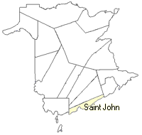
County location in province

 County map showing parishes
 Zoom in

Cadastral Maps
New Brunswick cadastral maps show the basic features of the province along with the boundaries, lot number, and grantee’s name for land granted by the province. These maps are cumulative, showing all grants regardless of date.
Zoom in

or
download
the full size version.
4912 x 3485 - 3.5 mb
|