Place Names of New Brunswick: Where is Home? New Brunswick Communities Past and Present
 Introduction |
  Alphabetical Listing |
  County Listing |
  Indexes |
  Definitions
 Skip Navigation Links
Located 6.71 km NE of
Saint-Quentin, on the Canadian National Railway line to
Kedgwick:
Saint-Quentin Parish,
Restigouche County: included the community of Arsenault Siding: PO
Arsenault Siding 1915-1970: included the settlement of St. Arthur: PO
St. Arthur 1934-1940: included the community of Lauvrière, which was named for Emile Lauvrière, a French writer of Acadian history: PO
Lauvrière 1940-1948: also included the settlements of St. Pierre and
Limerick: PO
Saint-Martin-de-Restigouche 1948-1970.
Latitude
:
47° 34'
Longitude
:
67° 20'
County
:
Restigouche
Parish
:
Saint-Quentin
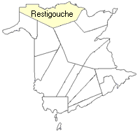
County location in province

 County map showing parishes
 Zoom in

Cadastral Maps
New Brunswick cadastral maps show the basic features of the province along with the boundaries, lot number, and grantee’s name for land granted by the province. These maps are cumulative, showing all grants regardless of date.
Zoom in

or
download
the full size version.
3669 x 2742 - 2.5 mb
|