Place Names of New Brunswick: Where is Home? New Brunswick Communities Past and Present
 Introduction |
  Alphabetical Listing |
  County Listing |
  Indexes |
  Definitions
 Skip Navigation Links
Located on E side of the St. John River, 12.19 km ENE of
Oromocto, on the road to
Maugerville:
Sheffield Parish,
Sunbury County: included Taylortown: PO 1857-1868: in 1866 Taylortown was a farming community with about 18 families, including the family of Stephen B. Taylor: PO
Upper Sheffield 1868-1914: in 1871 it had a population of 150: in 1898 Upper Sheffield had 1 post office, 1 store and a population of 75: became part of Sheffield.
Latitude
:
45° 53'
Longitude
:
66° 20'
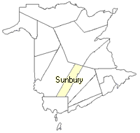
County
:
Sunbury
Parish
:
Sheffield
County location in province

 County map showing parishes
 Zoom in

Cadastral Maps
New Brunswick cadastral maps show the basic features of the province along with the boundaries, lot number, and grantee’s name for land granted by the province. These maps are cumulative, showing all grants regardless of date.
Zoom in

or
download
the full size version.
3722 x 2747 - 2.5 mb
|