Place Names of New Brunswick: Where is Home? New Brunswick Communities Past and Present
 Introduction |
  Alphabetical Listing |
  County Listing |
  Indexes |
  Definitions
 Skip Navigation Links
Located on W side of the St. John River, 3.71 km N of
Wakefield, on the road to
Somerville:
Wakefield Parish,
Carleton County: PO
Victoria from 1850: in 1866 Victoria Corner was a farming community with approximately 70 families: in 1871 it had a population of 350: in 1898 Victoria Corner had 1 post office, 1 store, 1 shoe factory and tannery, 2 churches and a population of 250: formerly called Bowyers Corner for Charles Bowyer, who was an early settler here.
Latitude
:
46° 16'
Longitude
:
67° 31'
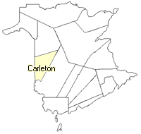
County
:
Carleton
Parish
:
Wakefield
County location in province

 County map showing parishes
 Zoom in

Cadastral Maps
New Brunswick cadastral maps show the basic features of the province along with the boundaries, lot number, and grantee’s name for land granted by the province. These maps are cumulative, showing all grants regardless of date.
Zoom in

or
download
the full size version.
3694 x 2760 - 2.5 mb
|