Place Names of New Brunswick: Where is Home? New Brunswick Communities Past and Present
 Introduction |
  Alphabetical Listing |
  County Listing |
  Indexes |
  Definitions
 Skip Navigation Links
Located on W side of the St. John River, 3.19 km NW of
Hampstead:
Hampstead Parish,
Queens County: William Francis Ganong identified the Maliseet name for Central Hampstead as M'dna'ak: first called Little River: PO
Little River 1856-1882: renamed Central Hampstead in 1882: PO
Central Hampstead 1882-1933: in 1898 Central Hampstead was a farming settlement with 1 post office, 1 cheese factory, 1 church and a population of 75.
Latitude
:
45° 38'
Longitude
:
66° 7'
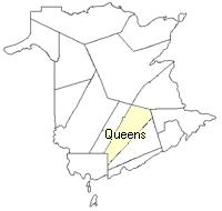
County
:
Queens
Parish
:
Hampstead
County location in province

 County map showing parishes
 Zoom in

Cadastral Maps
New Brunswick cadastral maps show the basic features of the province along with the boundaries, lot number, and grantee’s name for land granted by the province. These maps are cumulative, showing all grants regardless of date.
Zoom in

or
download
the full size version.
3680 x 2837 - 2.8 mb
|