Place Names of New Brunswick: Where is Home? New Brunswick Communities Past and Present
 Introduction |
  Alphabetical Listing |
  County Listing |
  Indexes |
  Definitions
 Skip Navigation Links
Located on N side of the Miramichi River, 1.26 km W of
Chatham Head and 8.45 km WSW of
Chatham:
Newcastle Parish,
Northumberland County: the name may be linked to Newcastle, England: PO from 1823: in 1871 Newcastle had a population of about 1,500: in 1898 Newcastle was a seaport, a port of entry, terminus of the Intercolonial Railway and a town with about 75 stores, 1 post office, 3 hotels, 2 foundries, 3 steam sawmills, 1 spool factory, 2 sash and door factories, planing mills, 1 machine shop, 1 quarry, 2 carriage factories, 1 printing shop, 6 churches and a population of 3,000: included
Northwest Bridge, located 3 km S of Newcastle: PO 1861-1968: in 1898 Northwest Bridge was lumbering and farming community with 1 post office, 1 store, 1 sawmill and a population of 300: Newcastle was incorporated as a town in 1899 and later became part of the city of
Miramichi.
Latitude
:
47° 0'
Longitude
:
65° 34'
County
:
Northumberland
Parish
:
Newcastle
County location in province

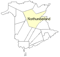 County map showing parishes
 Zoom in

Cadastral Maps
New Brunswick cadastral maps show the basic features of the province along with the boundaries, lot number, and grantee’s name for land granted by the province. These maps are cumulative, showing all grants regardless of date.
Zoom in

or
download
the full size version.
3763 x 2726 - 2.5 mb
|
Zoom in

or
download
the full size version.
2405 x 1798 - 1.4 mb
|