Place Names of New Brunswick: Where is Home? New Brunswick Communities Past and Present
 Introduction |
  Alphabetical Listing |
  County Listing |
  Indexes |
  Definitions
 Skip Navigation Links
Located 3.71 km S of
DeWolfe:
Saint James Parish,
Charlotte County: named for William Moore, a Loyalist from New Hampshire, who settled here about 1785 and built sawmills and grist mills: PO from 1854: in 1866 Moores Mills was a farming community with 80 families, including the families of George Moore, John A. Moore, John E. Moore, Nehemiah G. Moore, and Simon Moore: in 1871 it had a population of 300: in 1898 Moores Mills was a station on the Canadian Pacific Railway and a settlement with 1 post office, 1 store, 1 woodworking factory, 1 church and a population of 200.
Latitude
:
45° 18'
Longitude
:
67° 17'
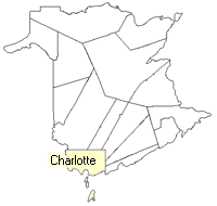
County
:
Charlotte
Parish
:
Saint James
County location in province

 County map showing parishes
 Zoom in

Cadastral Maps
New Brunswick cadastral maps show the basic features of the province along with the boundaries, lot number, and grantee’s name for land granted by the province. These maps are cumulative, showing all grants regardless of date.
Zoom in

or
download
the full size version.
3769 x 2960 - 2.8 mb
|