Place Names of New Brunswick: Where is Home? New Brunswick Communities Past and Present
 Introduction |
  Alphabetical Listing |
  County Listing |
  Indexes |
  Definitions
 Skip Navigation Links
Located on the St. John River, 1.3 km W of
Ononette:
Westfield Parish,
Kings County: originally known as Mouth of Nerepis: PO 1846-1895 with John M. Nase as an early postmaster: in 1866 Mouth of Nerepis was a farming community with about 90 resident families including 7 Belyea families: in 1871 it was a station on the European and North American Railway and had a population of 200: in 1898 Mouth of Nerepis was on the Canadian Pacific Railway line and had 1 store and a population of 150: PO
Westfield 1865-1891, and from 1895: in 1871 Westfield had a population of 200: in 1898 it was a farming settlement with 1 post office, 1 store, 1 hotel, 2 churches and a population of 150: the Canadian Pacific Railway station was called
Lingley : PO
Westfield Station 1876-1879: in 1871 Westfield Station had a population of 300: also included the communities of Ononette, Westfield Beach, Westfield Centre and
Ballentine: Westfield was incorporated as a village in 1972 and joined the town of Grand Bay in 1998 to form the town of Grand Bay-Westfield.
Latitude
:
45° 20'
Longitude
:
66° 14'
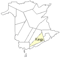
County
:
Kings
Parish
:
Westfield
County location in province

 County map showing parishes
 Zoom in

Cadastral Maps
New Brunswick cadastral maps show the basic features of the province along with the boundaries, lot number, and grantee’s name for land granted by the province. These maps are cumulative, showing all grants regardless of date.
Zoom in

or
download
the full size version.
3678 x 2934 - 2.5 mb
|