Place Names of New Brunswick: Where is Home? New Brunswick Communities Past and Present
 Introduction |
  Alphabetical Listing |
  County Listing |
  Indexes |
  Definitions
 Skip Navigation Links
Located 5.14 km E of
Dieppe and 7.71 E of
Moncton:
Moncton Parish,
Westmorland County: settled in 1820 by the Acasians it was originally called
le Brûlis du Lac: PO 1882-1960: in 1898 Lakeburn was a farming community with 1 post office, 1 church and a population of 150: Lakeburn became part of the town of Dieppe.
Latitude
:
46° 6'
Longitude
:
64° 41'
County
:
Westmorland
Parish
:
Moncton
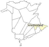
County location in province

 County map showing parishes
 Zoom in

Cadastral Maps
New Brunswick cadastral maps show the basic features of the province along with the boundaries, lot number, and grantee’s name for land granted by the province. These maps are cumulative, showing all grants regardless of date.
Zoom in

or
download
the full size version.
3650 x 2713 - 2.6 mb
|