Place Names of New Brunswick: Where is Home? New Brunswick Communities Past and Present
 Introduction |
  Alphabetical Listing |
  County Listing |
  Indexes |
  Definitions
 Skip Navigation Links
Located on the Gulf of St. Lawrence, 3.91 km SSW of
Shippagan:
Shippegan Parish,
Gloucester County: in 1842 this area was called New Jerusalem: included the communities of
Shippegan Gully Road and
Shippegan Gully: PO
Shippegan Gully 1904-1961: PO
Le Goulet from 1961: the village of Le Goulet was incorporated in 1986.
Latitude
:
47° 42'
Longitude
:
64° 43'
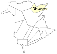
County
:
Gloucester
Parish
:
Shippegan
County location in province

 County map showing parishes
 Zoom in

Cadastral Maps
New Brunswick cadastral maps show the basic features of the province along with the boundaries, lot number, and grantee’s name for land granted by the province. These maps are cumulative, showing all grants regardless of date.
Zoom in

or
download
the full size version.
2849 x 3850 - 2.9 mb
|