Place Names of New Brunswick: Where is Home? New Brunswick Communities Past and Present
 Introduction |
  Alphabetical Listing |
  County Listing |
  Indexes |
  Definitions
 Skip Navigation Links
Located 3.21 km NW of
Back Bay and 3.71 km S of
Mascarene:
Saint George Parish,
Charlotte County: the area was probably named by the French "La tête" (the head of): PO
L'Etete 1856-1943: in 1866 Letete was a fishing and farming community with approximately 60 resident families: in 1871 it had a population of 200: in 1898 Letete had 1 post office, 2 stores, 1 church and a population of 400.
Latitude
:
45° 4'
Longitude
:
66° 54'
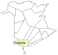
County
:
Charlotte
Parish
:
Saint George
County location in province

 County map showing parishes
 Zoom in

Cadastral Maps
New Brunswick cadastral maps show the basic features of the province along with the boundaries, lot number, and grantee’s name for land granted by the province. These maps are cumulative, showing all grants regardless of date.
Zoom in

or
download
the full size version.
2858 x 3795 - 1.7 mb
|