Place Names of New Brunswick: Where is Home? New Brunswick Communities Past and Present
 Introduction |
  Alphabetical Listing |
  County Listing |
  Indexes |
  Definitions
 Skip Navigation Links
Located on the St. Croix River, on the New Brunswick-Maine border, 3.93 km SSW of
St. Stephen:
Saint Stephen Parish,
Charlotte County: PO 1839-1975: established in 1760 and named Christie Town for Peter Christie: called Stillwater from 1785-c1800: in 1871 Milltown had a population of 1,400: at one time there were over 20 mills operating in this region: Milltown was incorporated as a town in 1878: in 1898 it was a port of entry, a station on the Canadian Pacific Railway and a town with 1 post office, 1 cotton mill employing 800 workers, 6 shingle and sawmills, axe and saw factories, 1 machine shop, 6 stores, 5 churches and a population of 2,200: in 1973 Milltown amalgamated with St. Stephen to form the town of
St. Stephen-Milltown.
Latitude
:
45° 10'
Longitude
:
67° 18'
County
:
Charlotte
Parish
:
Saint Stephen
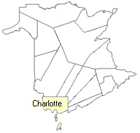
County location in province

 County map showing parishes
 Zoom in

Cadastral Maps
New Brunswick cadastral maps show the basic features of the province along with the boundaries, lot number, and grantee’s name for land granted by the province. These maps are cumulative, showing all grants regardless of date.
Zoom in

or
download
the full size version.
3769 x 2960 - 2.8 mb
|