Place Names of New Brunswick: Where is Home? New Brunswick Communities Past and Present
 Introduction |
  Alphabetical Listing |
  County Listing |
  Indexes |
  Definitions
 Skip Navigation Links
Located on the Bay du Vin, 3.79 km W of the community of
Bay du Vin, on the road to
Black River Bridge:
Hardwicke Parish,
Northumberland County: included Bayside: PO 1889-1940: in 1898 Bayside was a fishing and farming community with 1 store, and a population of 200: also included
Hexham: PO 1895-1952: in 1904 Hexham was a settlement with 1 post office, 1 store and a population of about 150: PO
Miramichi 1940-1970.
Latitude
:
47° 2'
Longitude
:
65° 11'
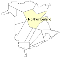
County
:
Northumberland
Parish
:
Hardwicke
County location in province

 County map showing parishes
 Zoom in

Cadastral Maps
New Brunswick cadastral maps show the basic features of the province along with the boundaries, lot number, and grantee’s name for land granted by the province. These maps are cumulative, showing all grants regardless of date.
Zoom in

or
download
the full size version.
3634 x 2759 - 2.2 mb
|