Place Names of New Brunswick: Where is Home? New Brunswick Communities Past and Present
 Introduction |
  Alphabetical Listing |
  County Listing |
  Indexes |
  Definitions
 Skip Navigation Links
Located 2.26 km NW of
Demoiselle Creek and 4.52 km SW of
Edgetts Landing:
Hillsborough Parish,
Albert County: settled in 1830: the mineral Albertite was discovered here in 1849 by Peter Duffy and John Duffy: this mineral was exported to Boston: PO 1855-1959: in 1866 Albert Mines was a mining and farming community with about 56 families: John Byers was manager of the Albert Mines: in 1871 it had a population of 200: in 1898 Albert Mines had 1 post office, 2 stores, 2 sawmills, 1 church and a population of 200: included PO
Albert Quarries 1858-1866.
Latitude
:
45° 52'
Longitude
:
64° 40'
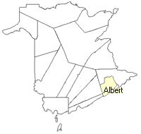
County
:
Albert
Parish
:
Hillsborough
County location in province

 County map showing parishes
 Zoom in

Cadastral Maps
New Brunswick cadastral maps show the basic features of the province along with the boundaries, lot number, and grantee’s name for land granted by the province. These maps are cumulative, showing all grants regardless of date.
Zoom in

or
download
the full size version.
3760 x 2767 - 2.4 mb
|