Place Names of New Brunswick: Where is Home? New Brunswick Communities Past and Present
 Introduction |
  Alphabetical Listing |
  County Listing |
  Indexes |
  Definitions
 Skip Navigation Links
Located on the Kouchibouguac Bay, 7.33 km ENE of
Rivière-au-Portage, on the road to
Escuminac:
Carleton Parish,
Kent County: settled in 1811: PO
Point Sapin 1873-1970: in 1866 Point Sapin was a farming and fishing settlement with approximately 34 resident families including 14 Daigle and 12 Mezeralle families: in 1871 Point Sapin had a population of 150: in 1898 Point Sapin had 1 post office, 1 store, several lobster factories, 1 sawmill, 1 church and a population of about 250: PO
Pointe-Sapin 1962-1970: also referred to as Pointe-au-Grand-Sapin.
Latitude
:
46° 58'
Longitude
:
64° 50'
County
:
Kent
Parish
:
Carleton
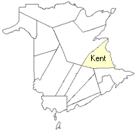
County location in province

 County map showing parishes
 Zoom in

Cadastral Maps
New Brunswick cadastral maps show the basic features of the province along with the boundaries, lot number, and grantee’s name for land granted by the province. These maps are cumulative, showing all grants regardless of date.
Zoom in

or
download
the full size version.
3800 x 2767 - 2.1 mb
|