Place Names of New Brunswick: Where is Home? New Brunswick Communities Past and Present
 Introduction |
  Alphabetical Listing |
  County Listing |
  Indexes |
  Definitions
 Skip Navigation Links
Located near Red Pine Brook, 16.73 km N of
Bartibog Station, on the Canadian National Railway line to
Bathurst:
Bathurst Parish and
Allardville Parish,
Gloucester County: PO 1901-1931: in 1898 Red Pine was a station on the Intercolonial Railway and a community with a population of 20.
Latitude
:
47° 26'
Longitude
:
65° 38'
County
:
Gloucester
Parish
:
Bathurst
County location in province

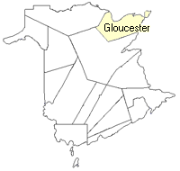 County map showing parishes
 Zoom in

Cadastral Maps
New Brunswick cadastral maps show the basic features of the province along with the boundaries, lot number, and grantee’s name for land granted by the province. These maps are cumulative, showing all grants regardless of date.
Zoom in

or
download
the full size version.
3675 x 2686 - 1.6 mb
|