Place Names of New Brunswick: Where is Home? New Brunswick Communities Past and Present
 Introduction |
  Alphabetical Listing |
  County Listing |
  Indexes |
  Definitions
 Skip Navigation Links
Located 11.74 km WSW of
Oromocto:
Lincoln Parish,
Sunbury County (pronounced "rah-sha-gor-nish"): William Francis Ganong identified the Maliseet name for Rusagonis as Tesegwan'ik: settled in 1784: PO
Rusagornis 1853-1930: in 1866 Rusagornis was a farming community with approximately 52 families: in 1871 Rusagornis and surrounding district had a population of about 200: in 1904 Rusagornis had 1 post office, 1 store, 1 church and a population of 75: PO
Rusagonis 1930-1959.
Latitude
:
45° 48'
Longitude
:
66° 37'
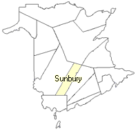
County
:
Sunbury
Parish
:
Lincoln
County location in province

 County map showing parishes
 Zoom in

Cadastral Maps
New Brunswick cadastral maps show the basic features of the province along with the boundaries, lot number, and grantee’s name for land granted by the province. These maps are cumulative, showing all grants regardless of date.
Zoom in

or
download
the full size version.
3616 x 2746 - 2.5 mb
|